Rock Slope Stability and Failure Modelling in Melbourne!
Ensuring Safe Development in Challenging Terrain
While Melbourne is known for its urban sprawl and flat landscapes, the surrounding regions — including the Dandenong Ranges, Yarra Valley, and Mornington Peninsula — present unique rock slope stability challenges for engineers, builders, and councils alike.
Unstable rock slopes can pose serious risks to infrastructure, transport corridors, residential developments, and public safety. At OzGeos, we use advanced rock slope stability analysis and failure modelling to assess and mitigate these risks — helping to ensure that developments in hilly or geologically complex areas remain safe, compliant, and sustainable.
Why Rock Slope Stability Matters in Melbourne
Though the central city is relatively flat, outer Melbourne and regional Victoria are home to:
- Basalt escarpments and volcanic formations
- Weathered sedimentary cliffs and cut slopes
- Granite and metamorphic rock outcrops in hilly terrain
- Road and rail cuttings carved into rock slopes
These features can become unstable due to natural weathering, groundwater flow, seismic activity, or human activities such as excavation or land clearing.
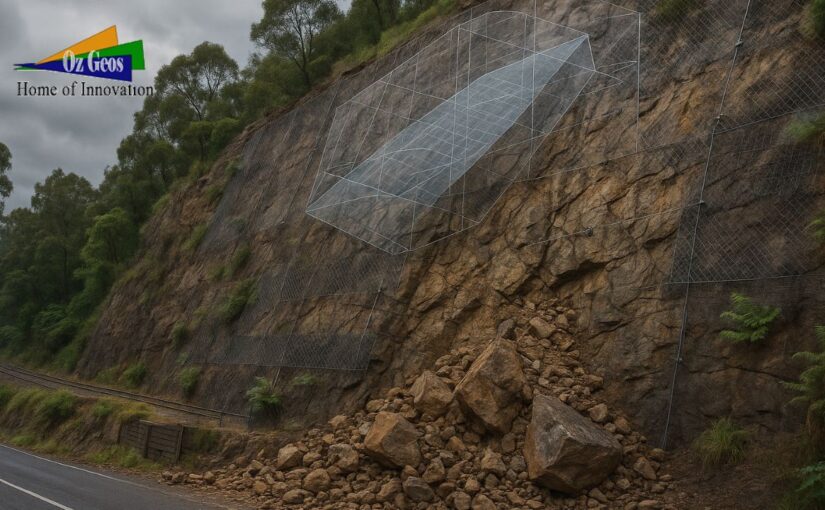
Real-world consequences of rock slope failure include:
- Landslides impacting roads or railways
- Rockfalls damaging property and infrastructure
- Slope instability near cuttings, quarries, or retaining structures
- Soil and rock creep affecting long-term stability
Common Triggers of Rock Slope Instability
- Weathering and erosion of rock faces
- Seepage or increased groundwater pressure
- Vegetation removal or deforestation
- Earthworks or blasting near slopes
- Undercutting or excavation at slope toe
- Heavy rainfall events due to climate change
These conditions are increasingly common across Victoria, particularly in high rainfall regions or where infrastructure cuts through steep terrain.
How We Assess and Model Rock Slope Stability
At OzGeos, we follow a systematic approach in line with Australian and international geotechnical standards.
1. Site Investigation and Geological Mapping
- Identifying rock types, fractures, joints, bedding planes
- Mapping discontinuities and assessing their orientation
- Reviewing existing slope geometry, natural and man-made
2. Laboratory and In-situ Testing
- Uniaxial compressive strength (UCS)
- Point load testing
- Direct shear testing on joint samples
- Permeability and porosity analysis
These tests help us determine rock mass strength and degradation potential.
3. Rock Mass Classification
We use systems such as:
- RMR (Rock Mass Rating)
- Q-system (Barton’s method)
- GSI (Geological Strength Index)
These allow for quantifying rock mass conditions and selecting appropriate support systems.
4. Stability Analysis and Failure Modelling
Using advanced software tools like:
- Rocscience Slide2
- RocPlane
- GeoStudio
- PLAXIS 3D
We model:
- Plane, wedge, and toppling failures
- Global slope stability
- Factor of safety under various conditions (wet, dry, seismic)
- Retention and reinforcement options (rock bolts, shotcrete, anchors)
Mitigation and Remediation Techniques
Depending on the risk level and design requirements, we recommend tailored solutions such as:
- Rock bolting and anchoring
- Shotcrete lining or mesh drapery
- Drainage installation (weep holes, horizontal drains)
- Retaining walls or soil nails
- Catch fences or barriers for rockfall protection
- Vegetative cover or hydroseeding to reduce erosion
Every mitigation plan is site-specific and backed by thorough modelling.
Compliance with Australian Standards
Our investigations and recommendations align with:
- AS 1726 – Geotechnical Site Investigations
- AS 5100.3 – Bridge Design – Geotechnical Aspects
- ANCOLD Guidelines – Where applicable to slopes near dams
- Local government overlays, including Erosion Management and Landslide Risk Overlays
We also support council submissions, planning permits, and risk assessments required under the Victorian Planning Provisions (VPP).
Why Choose OzGeos for Rock Slope Assessment?
✔️ Specialists in Victorian geology and terrain
✔️ Experienced in both urban and regional risk zones
✔️ Advanced failure modelling using industry-grade software
✔️ Responsive reports for planning, construction, and compliance
✔️ Collaborative approach with structural and civil engineers
Whether you’re building on a hillside block or managing an infrastructure corridor, we’ll help you understand the ground risks and manage them with confidence.
Plan Smart, Build Safe
Rock slope instability is a silent threat that can be managed — but only with proper investigation and modelling. At OzGeos, we provide the technical expertise and local knowledge to ensure your project remains grounded in safety and compliance.
📞 Get in touch today to discuss a site-specific slope assessment or rock stability investigation across Melbourne and regional Victoria.